UN Embraces the Equal Earth Map – Africa Gets Its Real Size Back
- Nishadil
- September 06, 2026
- 0 Comments
- 3 minutes read
- 21 Views
- Save
- Follow Topic

UN backs a new world map that finally shows Africa’s true scale and challenges the old Mercator distortion
A UN resolution backed by 164 nations, including India, promotes the 2018 Equal Earth projection to replace the Mercator map’s size bias, especially toward Africa.
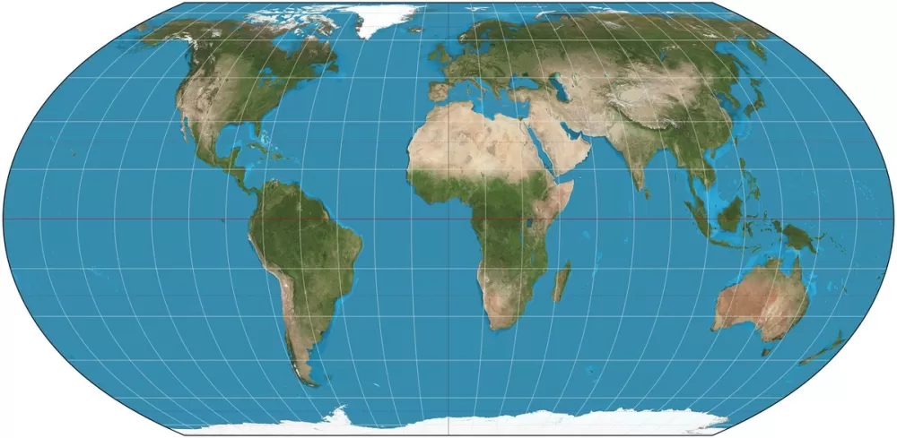
The United Nations voted this week to give the world a map that looks a lot less like a sailor’s cheat sheet and a lot more like the planet we actually live on. 164 countries – India among them – threw their support behind the Equal Earth projection, a design that was first published in 2018 and that aims to show the relative size of continents without the grotesque stretching that the centuries‑old Mercator map imposes.
Why does this even matter? Well, the Mercator projection was invented by Gerardus Mercator in 1569 to help ships plot straight‑line courses. It does that brilliantly, but at a price: every landmass gets reshaped. The farther a region sits from the equator, the more it balloons on paper. That’s why Canada, Russia and Europe look gigantic, while Africa, the world’s second‑largest continent, looks oddly squashed. A classic example that still trips people up is the comparison between Greenland and Africa – on a Mercator map the two appear almost the same size, yet Africa is roughly fourteen times larger.
The Equal Earth map is an "equal‑area" projection, meaning it preserves the true area of each piece of land. Africa suddenly stretches out, taking up the space it deserves alongside Europe and North America. Of course, no flat map can be perfect. By choosing to keep areas accurate, the projection sacrifices some shape fidelity and distance accuracy, especially toward the poles – but that trade‑off feels acceptable to most cartographers who see the visual bias of Mercator as a lingering form of "cartographic colonialism".
The push for change didn’t start in the UN chambers. It began in Africa, with Togo speaking on behalf of the African Union and championing the #CorrectTheMap campaign. Activists argue that the Mercator bias subtly reinforces a Western‑centric worldview, influencing everything from school textbooks to geopolitical perception. Giving Africa its proper visual weight, they say, is a step toward decolonising education and global narratives.
Will every map suddenly flip to Equal Earth? Not right away. The UN resolution is non‑binding, so no country or corporation is forced to abandon Mercator overnight. Still, the vote sends a clear signal. Some organisations have already moved. Google swapped its desktop view to a 3‑D globe in 2018 (though Mercator still powers the mobile app), the World Bank prefers the Winkel Tripel or Equal Earth for its static graphics, and France announced it will phase out Mercator in favour of the Eckert IV projection.
Looking ahead, Togo plans talks with UNESCO, the African Union and tech giants like Google Maps to explore how quickly the new projection can be rolled out in education and digital platforms. In short, the UN’s endorsement isn’t a ban on Mercator – it’s an invitation to rethink the way we picture our planet, acknowledging that a perfectly flat map will always involve compromises, but that we can at least get the areas right.
Editorial note: Nishadil may use AI assistance for news drafting and formatting. Readers can report issues from this page, and material corrections are reviewed under our editorial standards.