India on Alert: Low‑Pressure System Over Bay of Bengal May Grow Into a Cyclone
- Nishadil
- October 23, 2026
- 0 Comments
- 2 minutes read
- 5 Views
- Save
- Follow Topic
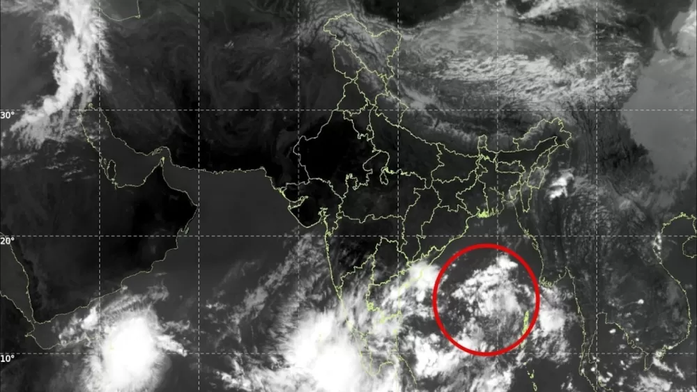
Low‑pressure area spotted over Bay of Bengal; experts watch for possible cyclone development
A developing low‑pressure system over the Andaman Sea could evolve into a tropical cyclone, prompting coastal states to stay on guard.
Early on October 22, meteorologists at the India Meteorological Department (IMD) noticed a fresh swirl of air lingering over the North Andaman Sea. At roughly 5:30 a.m. IST, the upper‑air cyclonic circulation was already pushing west‑northwest, hinting at something that could become a bigger story in the days ahead.
What we’re really looking at is a classic low‑pressure area – a common feature over warm tropical waters. When the sea‑surface temperature is high, moisture plentiful and the wind patterns cooperate, these humble pockets can blossom into organized thunderstorms, and sometimes, into full‑blown cyclones. That’s the textbook scenario, and right now the ingredients are stacking up.
The IMD’s latest outlook says the system should drift west‑northwestwards, potentially settling over the southeast and east‑central Bay of Bengal by October 23. From there, it may keep moving in the same direction, gaining strength as it goes. The exact trajectory, though, is still a matter of speculation – it could stall, veer off, or keep marching toward the Indian coast.
Why does this matter? Because the Bay of Bengal is a notorious breeding ground for post‑monsoon cyclones. October through December is the peak window, when ocean waters stay warm enough to fuel storms. If this low‑pressure area deepens into a well‑organised depression, the odds of it turning into a tropical cyclone rise sharply. But let’s be clear – a low‑pressure centre alone does not guarantee a cyclone.
Should the system intensify, coastal regions along India’s eastern seaboard could feel the impact: heavier rain, gusty winds and choppy seas. The Andaman and Nicobar Islands are also in the line of fire, given their proximity to the system’s birthplace. At this stage, though, there’s no confirmed landfall point, nor a specific state that’s flagged as most vulnerable. Forecasts will sharpen as the system evolves, and the IMD will keep issuing updates.
In practical terms, the warning means authorities and coastal communities should stay tuned to the latest bulletins, prep emergency kits just in case, and keep an eye on any changes in the system’s intensity or track. It’s a classic “watch‑and‑wait” situation – the next few days will tell whether this weather quirk becomes a genuine threat.
For now, the low‑pressure area remains a weather feature to monitor, not a headline‑making cyclone. But given the region’s history, a cautious eye is well‑warranted.
- India
- News
- Environment
- EnvironmentNews
- HeavyRainfall
- TropicalCyclone
- LowPressureSystem
- LowPressureArea
- AndamanAndNicobarIslands
- ImdWeatherUpdate
- BayOfBengalCyclone
- AndamanSeaWeather
- IndiaMeteorology
- RoughSeaConditions
- IndiaCycloneAlert
- PostMonsoonStorms
- EasternCoastWeather
- AndamanSeaWeatherSystem
- TropicalCycloneWarning
- EasternIndianCoast
Editorial note: Nishadil may use AI assistance for news drafting and formatting. Readers can report issues from this page, and material corrections are reviewed under our editorial standards.